Mapping | GIS

Update to WisCORS and MODOT RTK Networks

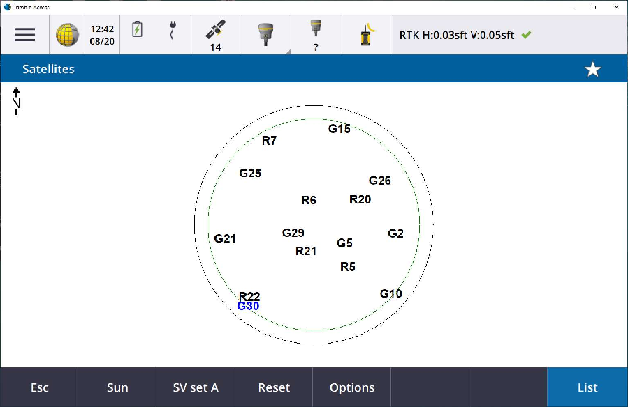
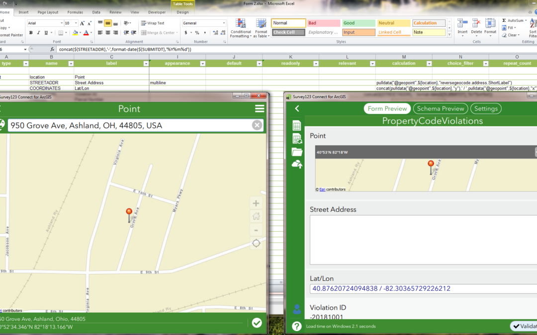
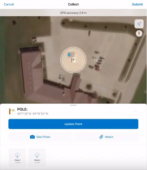
Recently both Wisconsin and Missouri have made changes to their RTK networks to add advanced mountpoints to include more satellite constellations. For the field worker this means more satellites to collect data in the field and keep consistent accuracy in the Field. All you need to do it update your server mount point inside your [...]

By |2024-01-22T09:21:50-06:00January 22nd, 2024|Mapping | GIS|0 Comments

Trimble DA2 GNSS Firmware – Release Notes and How to Install Latest GNSS Firmware

Here are some resources per the Trimble DA2 GNSS Firmware: Trimble Community – Mapping/GIS User Group. Sign in with your Trimble ID to “Follow” when a New DA2 GNSS Firmware is released: https://community.trimble.com/viewdocument/trimble-catalyst-da2-firmware-relea?CommunityKey=2724bc18-0fbe-4f63-a41c-4a5fa6264382&tab=librarydocuments DA2 GNSS Firmware Release Notes: https://help.trimblegeospatial.com/Catalyst/DA2-firmware-releases.htm Video: How to install the DA2 GNSS Firmware: https://www.youtube.com/watch?v=cQZgZi6uS9o DA2/Catalyst Help: https://help.trimblegeospatial.com/Catalyst/DA2-update.htm   For more information [...]

By |2023-12-12T13:19:59-06:00December 6th, 2023|Mapping | GIS|0 Comments

Best Practices For GNSS Data Collection – Podcast

Want to learn Directly from the Trimble Experts? Listen to this Esri "Field Notes" Podcast about: Best Practices For GNSS Data Collection Timestamps for the Pod Cast: 2:57—Difference between GPS and GNSS 4:27—Examples of when high-accuracy data collection is necessary 7:00—Additional value of using GNSS receivers 11:00—What to consider when preparing for GNSS data collection [...]

By |2023-08-01T15:11:18-05:00August 1st, 2023|Mapping | GIS|0 Comments

Seiler Summer Series – July and August 2023

Join us for our Seiler Summer Series in July and August. Where? Illinois, Iowa, Wisconsin and Kentucky. You will hear from our Seiler Experts in the following markets: Public Safety, Design Solutions/CAD, Geodrones and Geospatial: Mapping/GIS and Survey. The events are Free Outside demonstrations (weather permitting) See our Events Page for more information and how [...]

By |2023-07-21T10:15:59-05:00July 21st, 2023|Mapping | GIS|0 Comments

5 Reasons why Utilities use GNSS for Better Asset Management

Trimble recently published a Customer Story/Blog  "5 Reasons Utilities Use GNSS Positioning Services for Better Asset Management" Utilities are increasingly moving toward digital solutions that enable them to effectively measure, monitor and manage widespread networks of critical assets. They need a complete solution that enhances their ability to document information accurately and quickly, a short [...]

By |2023-05-04T15:29:19-05:00May 4th, 2023|Mapping | GIS|0 Comments

Effects of 3G WWAN Network Retirements per Trimble Products

See the following link on the Trimble Mapping and GIS Solutions Community per the retirement of 3G WWAN Networks per Trimble Products There is a PDF that can be downloaded with more information in the thread. The following key US and European carriers/service providers published their plans to retire their 3G WWAN infrastructure: ● AT&T [...]

By |2023-02-10T11:40:37-06:00February 10th, 2023|Mapping | GIS|0 Comments

GNSS Firmware for Trimble DA2/Catalyst

The latest GNSS Firmware for the Trimble DA2/Catalyst as of November 2nd 2022 is v1.50.             Here are 4 resources to stay up to date and how to install the current GNSS Firmware release for the Trimble DA2: Mapping and GIS Solutions Community website: Trimble DA2 GNSS Firmware Releases  Log [...]

By |2022-11-21T15:34:24-06:00November 21st, 2022|Mapping | GIS|0 Comments
Go to Top